
WillyWeather


Click to download now, finish the installation quickly, and directly unlock the "all-round experience"
About This App
🏆 Expert Verdict & Overview
WillyWeather distinguishes itself as a premier, data-driven hyper-local forecasting platform. While many apps serve general weather needs, WillyWeather carves out a dominant position for the US market by focusing on the granular details that matter to outdoor professionals and enthusiasts. By processing and tailoring NOAA data for over 175,000 specific coordinates, it moves beyond generic city forecasts to deliver actionable intelligence for specific beaches, trails, and waterways. It transitions from being merely an "app" to a critical planning tool for activities dependent on precise environmental conditions.
🔍 Key Features Breakdown
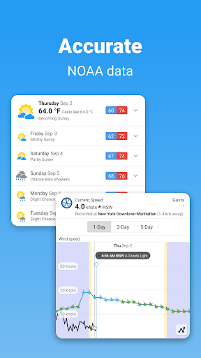
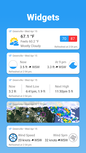
- Hyper-Local Tide & Swell Data: This solves the core problem of outdated, generic tide charts by integrating NOAA port data with custom-calculated offsets for every US beach and many rivers, providing surfers, fishers, and boaters with reliable, location-specific water condition forecasts.
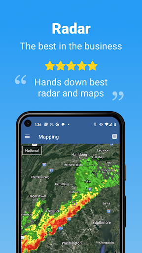
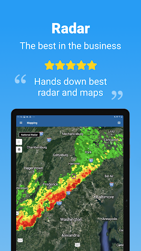
- NOAA Radar & Satellite with Google Maps Integration: Addresses user frustration with clunky, low-resolution radar by offering a pan-and-zoom interactive map, delivering precise, real-time visualization of precipitation and cloud cover for micro-level storm tracking and planning.
- Interpolated Wind Forecasts: Tackles the inaccuracy of broad wind models by taking NOAA's global data, refining it to exact coordinates, and validating it against real-time observations, offering unmatched reliability for sailors, pilots, and wind-sensitive outdoor sports.
- Context-Rich Interactive Graphs: Solves the problem of interpreting raw weather data by presenting tide, swell, and wind forecasts in beautiful, interactive graphs, allowing users to quickly visualize trends and optimal time windows for their activities over a 7-day period.
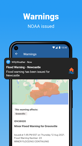
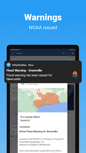
- Targeted NOAA Warnings & Real-Time Observations: Moves beyond region-wide alerts by delivering warnings and current conditions (feels-like temp, rain last hour, gusts) specifically for saved locations, ensuring users receive only the most relevant and critical safety information.
🎨 User Experience & Design
The app's stated goal of a "beautiful, simple, and organized interface" is well-executed for its target power users. It adeptly manages a massive volume of diverse data points—from UV indexes to moon illumination—without overwhelming the user. The tabbed or sectioned organization logically separates general weather, marine data, and astronomical information. The interactive graphs and maps are the UX centerpiece, transforming complex datasets into intuitive and actionable visual tools. This design philosophy prioritizes depth and utility over minimalist simplicity, perfectly aligning with the high-information needs of its core audience in the weather category.
⚖️ Pros & Cons Analysis
- ✅ The Good: Unrivaled depth and accuracy of hyper-local data for US locations, especially for tides, swell, and wind.
- ✅ The Good: Exceptional, interactive data visualization tools (graphs, maps) that make professional-grade data accessible.
- ✅ The Good: Comprehensive integration of disparate NOAA data streams into a single, cohesive planning platform.
- ❌ The Bad: Exclusive focus on the United States limits its utility for international travelers or users abroad.
- ❌ The Bad: The sheer volume of data and features may present a steep learning curve or feel excessive for users seeking only basic daily forecasts.
🛠️ Room for Improvement
Future development should focus on enhancing accessibility for a broader user base without compromising its core power. Introducing a "Simple Mode" that surfaces only temperature, precipitation chance, and severe alerts would cater to casual users. Expanding coverage to include major international coastal regions would be a significant value-add for travelers. Furthermore, integrating user-submitted condition reports (e.g., surf cams, trail reports) could create a powerful community-driven verification layer on top of the robust forecast data.
🏁 Final Conclusion & Recommendation
WillyWeather is not for everyone, and that is its greatest strength. It is the definitive recommendation for US-based outdoor professionals, mariners, serious surfers, anglers, hikers, and pilots—anyone whose safety, success, or enjoyment depends on precise, localized environmental intelligence. For the average user checking if they need an umbrella, it is overkill. However, for its target audience, it is an indispensable tool that provides a clear competitive edge through superior data depth, accuracy, and presentation.
Best Similar Apps